In late August we received a call from our friend Tracy who lives near Tuscon. She was fortunate enough to receive a permit to go visit Havasupai Falls. Right after she had gotten the permit which is very difficult to get, Covid shut down the trail to the falls and the permit was put on hold. Three years later she got the go ahead to do the hike. Her original hiking partner was unable to do the hike so she contacted us. She knew that we were headed to Arizona to finish our hike of the Arizona Trail late Sept. and thought that I might be interested to do the Havasupai hike before the Arizona trail hike. The permit was only for two people so I quickly opted to go. We left Alaska on Sept. 5, spent a week with Jeff in Oregon and then by Sept. 20 we were meeting up with Tracy at the Grand Cavern Inn. Don and I stayed in the campground while Tracy opted for a room at the Inn. Tracy checked in at the office and got our bracelets which we will wear when visiting the Falls. There is no camping at the trailhead which is 60 miles from where we are staying. Our plan is to leave the Inn by 5 am and hope to be at the trailhead by 6:30. Hikers often opt to hike earlier than that, but it has been cooling off and we want to see the beauty of the canyon.
Havasupai means people of the blue-green water. There are several spectacular waterfalls and an isolated community within the Havasupai Indian Reservation.These falls attract thousands of visitors each year. The permit window opens in Feb. and is often filled with in an hour. I feel fortunate to experience this area.
Sept. 21
At 5 we pull out of the parking lot and head to the paved road which will lead up to the trailhead. It is still dark and we drive slowly to make sure we miss hitting the black free range cattle. We do, however, make contact with bats that seem to unfortunately fly into our windshield. About 45 miles in there is a checkpoint that makes sure we have the right permits to continue on the road. We do and the cones were removed to let us enter. Twenty minutes later we find ourselves at the trailhead and are surprised to see a very full parking lot. There are several other groups of hikers here to begin their hike. This hike is often done as a first backpacking trip and it was obvious that some of the hikers were quite new to this activity. We decide that Tracy will drop me and the backpacks off at the trailhead and she will go find a secure place to park the car. We have been told that one should not park near a cliff as cars have been damaged by rock fall. Tracy finds a spot and then gets picked up by an older gentleman who was at the check in on the road. That was a good way to start the day. There is a pile of gear near the trailhead. One of the options for the hike is only to take a small day bag and let mules carry your gear to the campground. There is also an option of taking a 10 minute ride on a helicopter to the village. We are hiking the whole way with our backpacks!

The trailhead photo.
The first two miles are rather steep as the trail switchbacks down to the canyon floor. We meet several groups of hikers that have left quite early from the campground to make it up to the trailhead before it gets hot. We make a note of this to help up plan for our departure in a couple of days.
We make it to the canyon floor and are grateful that we are still walking in the shade.

Down we go!

Our pace is steady, with few stops as once the sun hits us we will feel the heat.

The trail is rocky, and has a slight down grade. The views are spectacular!
We meet several groups of mules hauling gear back to the trailhead and then the hikers with small day bags.

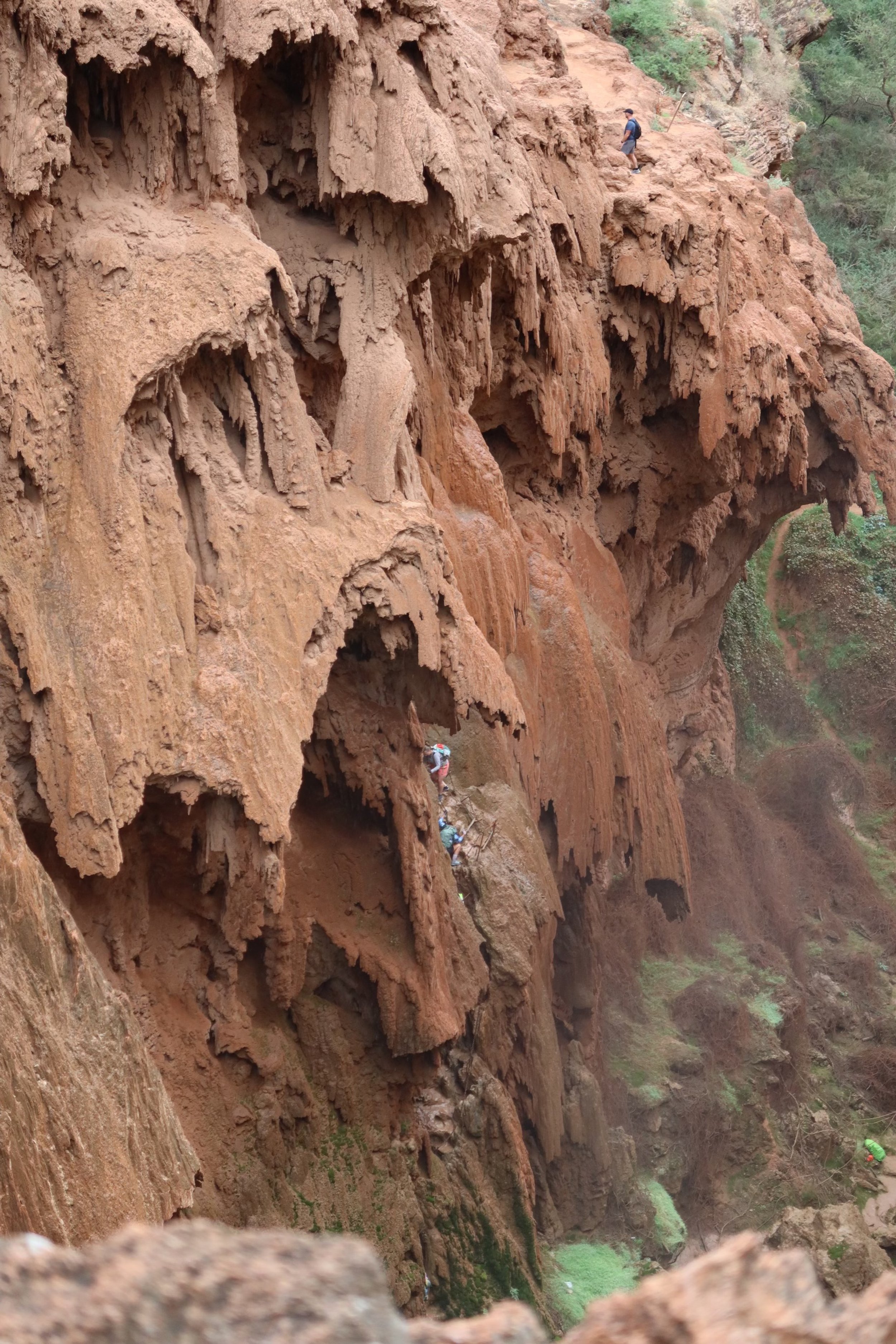
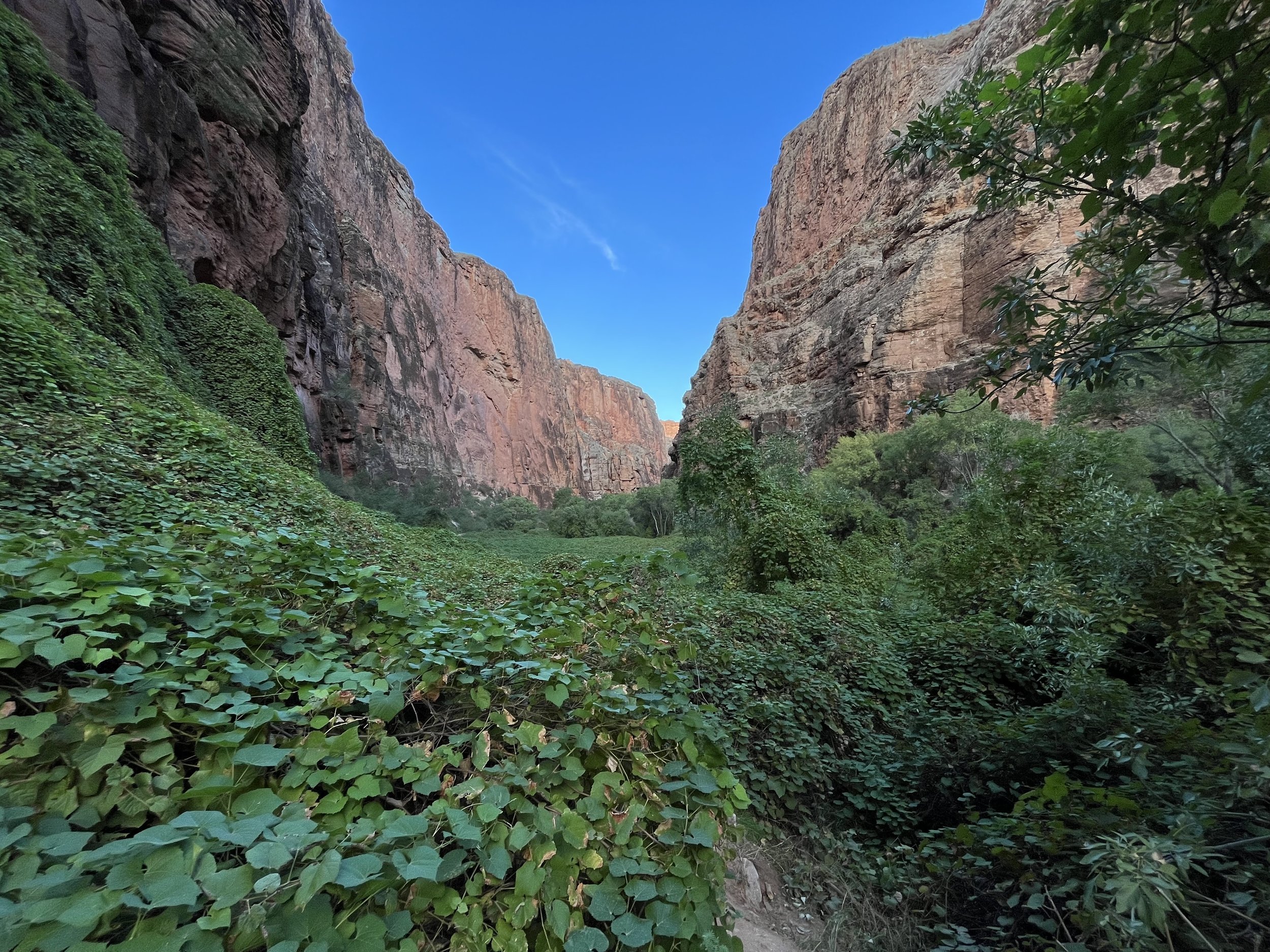
Several miles before the Village the canyon comes alive with vegetation.

There is a small stream with a bridge to cross it. There is a blue tint to the water. The sign causes us pause as we haven’t seen many people that would make us need to take turns.

I am ready with my trekking poles in case we do!
After hiking about 8 miles we see the outskirts of the village. There are signs warning us that no photos are to be taken of the village or of the people. When we arrive to the town square there is a ceremony. The Havasupai were dressed in ceremonial clothes with several of the men wearing sheep horns. There is drumming and the people of the village are doing a circle dance. One of the men with a loud speaker invites everyone to join the circle. We do and spend some time walking to the beat of the drum. After the circle dance we have two more miles to get to the beginning of the campground. The trail now is quite sandy and our pace is slower. First we pass Navajo falls below us and stop for a lunch break. Several people are swimming here and we look forward to swimming there at some point. First though we need to get to the campground and find a site.
We pass by the ranger station and are a bit dismayed by all of the items that are left behind by hikers.

There is a sign saying please pack out what you bring in, but that direction doesn’t seem to be followed.
We also pass by the Fry Bread Tent with this sign.

It is opened today and we plan to stop by sometime during our stay. It smells good. We love the sign.
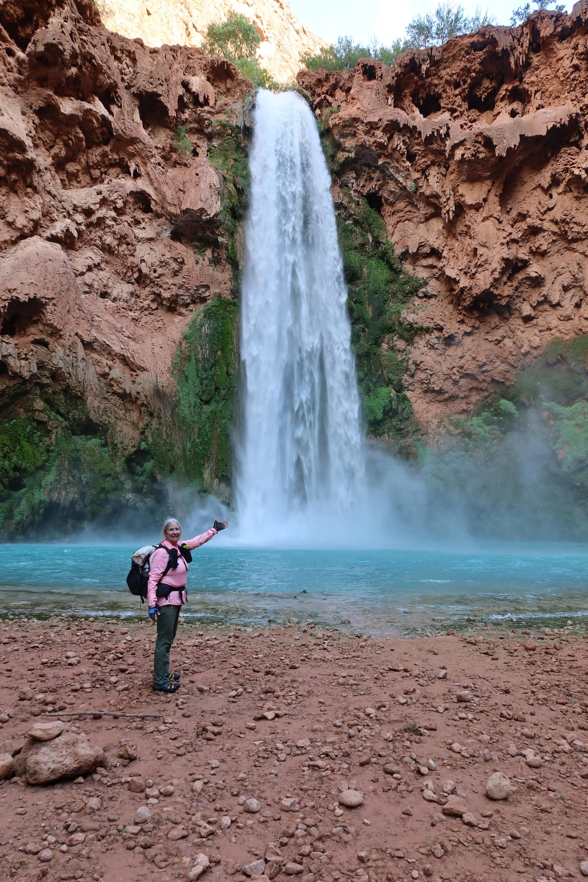
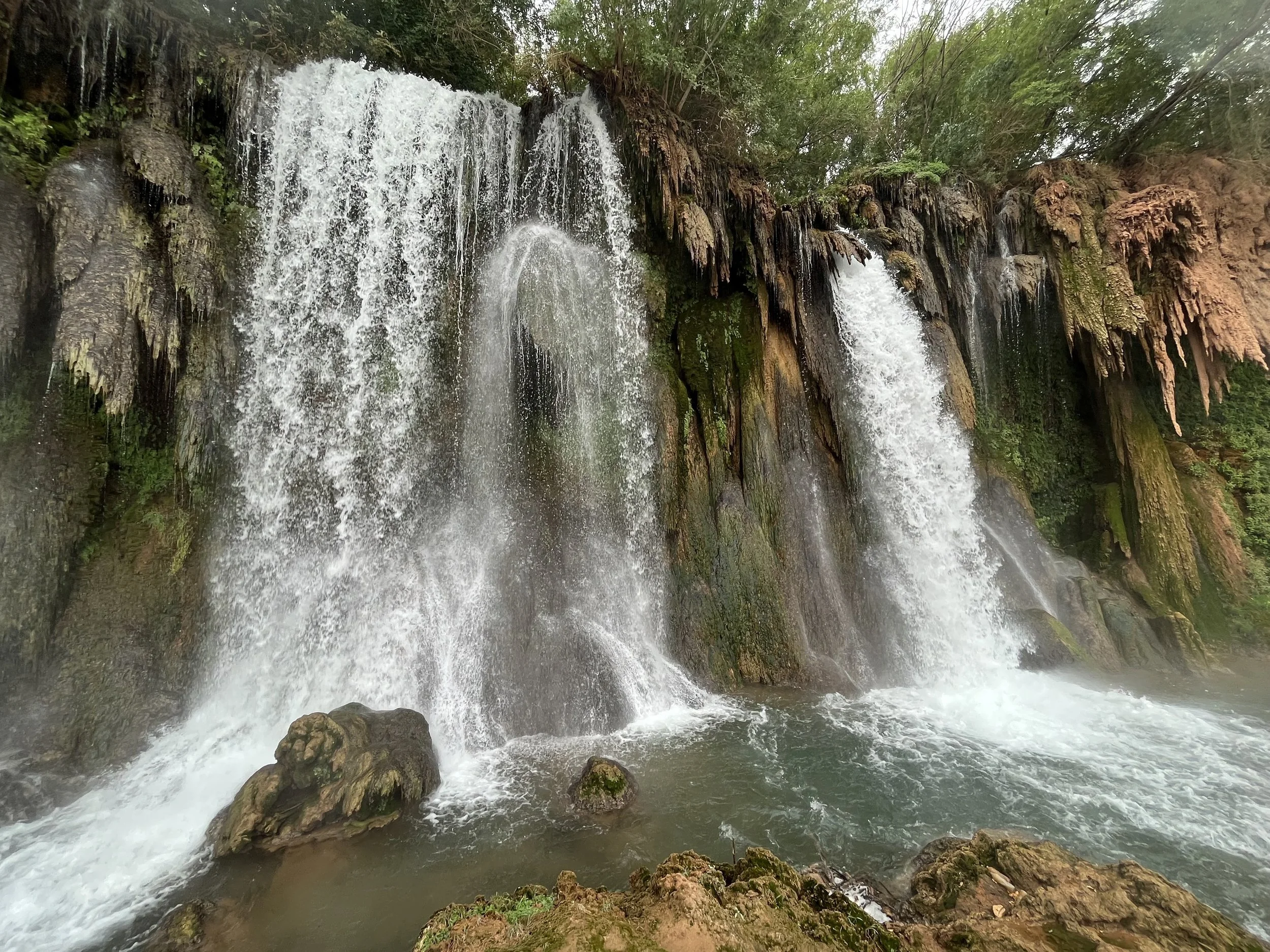
We hear some falls and then see the Havasupai Falls. This fall is the closest to the camp ground, we stop and are awed by its beauty. We plan to return here after setting up our tent.
The campground is packed with tents everywhere. Some spots have picnic tables and some are quite near the water. From some reading that we have done about selecting a site is that keep walking till you get past the third bathroom. Many hikers are so glad to reach the campground that the first open site they see they take it. We actually didn't need to use that option as it didn’t seem that there were any open sites. Our options were limited until we got to the trail right before heading down to Mooney Falls. We were at the end of the campground which is over a mile long. Finally several picnic tables with empty sites were available. The wind had picked up but by working together the tents got set up.

We are about 10 feet from a cliff that overlooks Mooney Falls. It is quite the site and we are glad we waited.
It doesn’t have any close trees so we walk to a neighboring site and secure our food between two trees. We have been warned that the mice and squirrels here are quite adapt at eating your food if it is not secured well.
With tents pitched and food secured, we put our swim suits on and walk the mile back to the falls. We also take our water bottles to fill them at Fern Springs which is the water source for the campground

We check out the falls from above before heading down to the pool to go swimming.
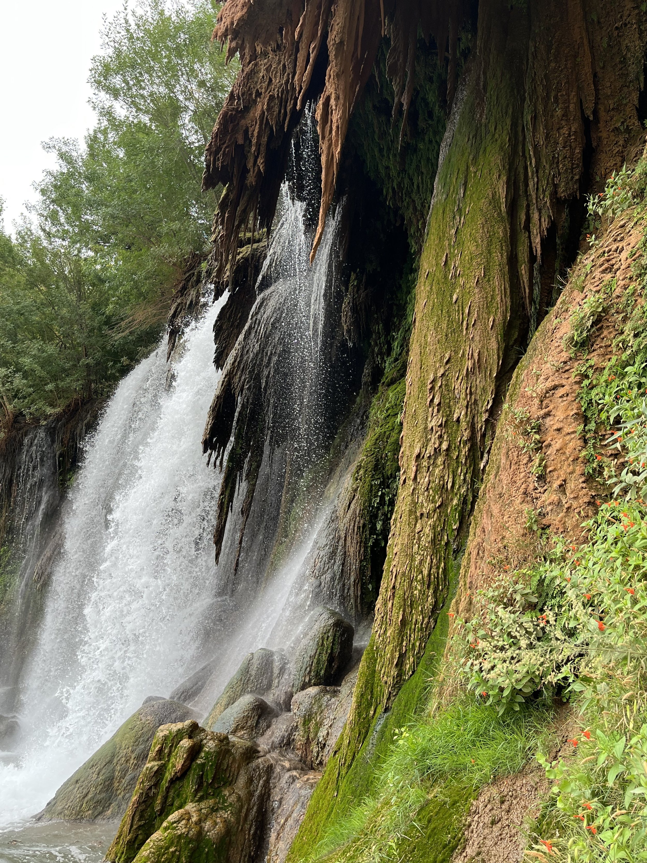
The color of the water is caused by the mineral travertine. As the water flows over the rock it picks up the coloring. It hasn’t rained in a couple of days so the water is a deep blue.
The water temperature is around 70 degrees. It seemed like most of the people here thought that it was cold, but being from Alaska I thought it was quite refreshing. The power of the water coming over the falls created a strong current and getting close to the falls was challenging. I didn’t even try.
It was hard to want to leave this magical place, but the plan was for us to hike to the Confluence tomorrow. The Confluence is where the Havasupai river flows into the Colorado. We planned for an early start so wanted to do some prep work tonight. Headed to bed and had the sound of Mooney falls drowning out all sounds.

This is our picnic table at our campsite. It was quite the drop off on the other side of the picnic table.
Sept. 22
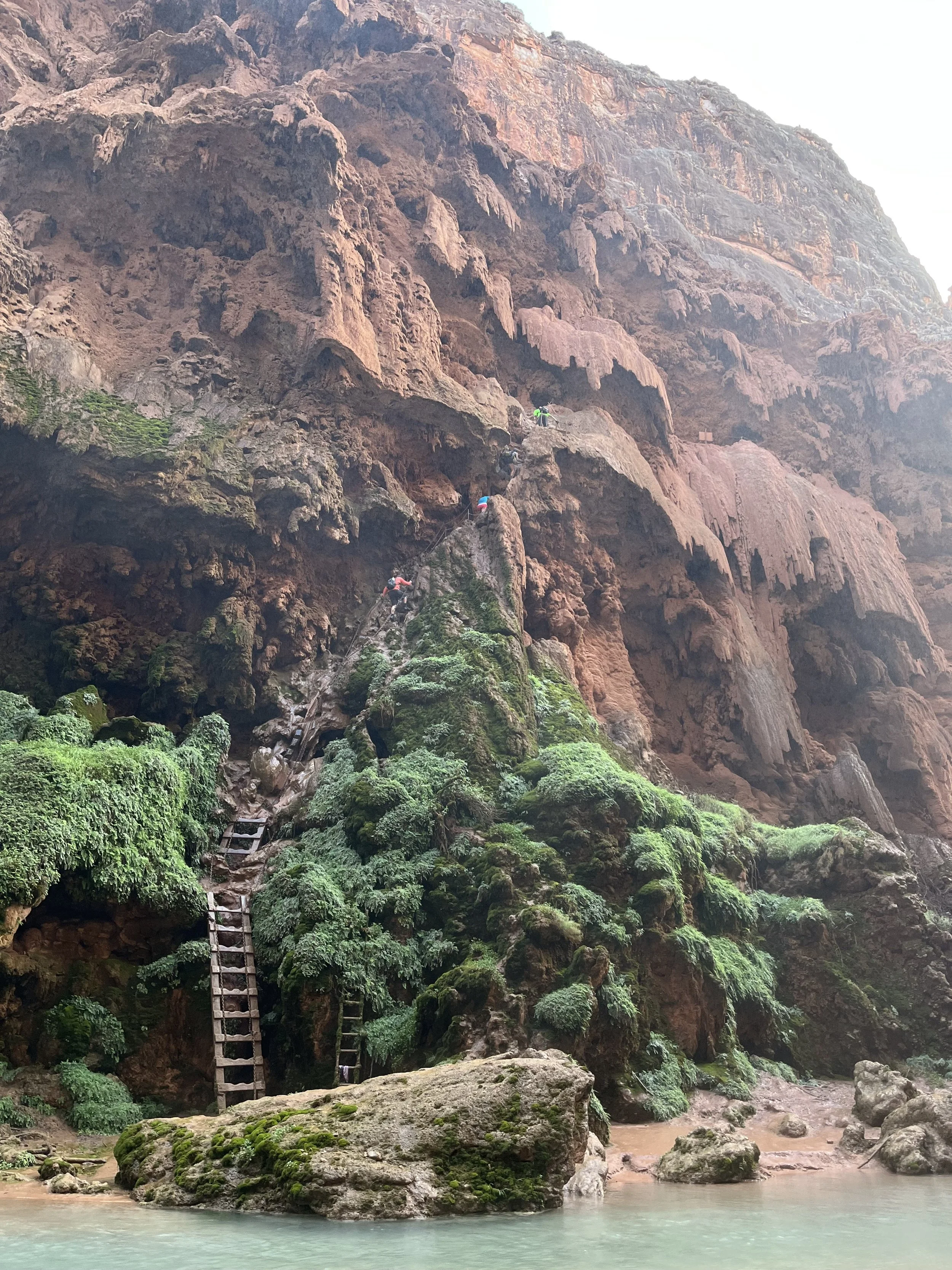
We were up at 6 and ready to head down the cliff to Mooney falls by first light. As we were eating breakfast in the dark a group of hikers with head lamps headed down to the cliff which is how one has to descend to Mooney Falls.
The cliff has chains and rebar to help with the descent, but it is still tricky and one needs to move slowly. We talked to several campers that got to the cliff and decided that that was something they didn’t want to do.
Looking at Mooney Falls before we descended.

The group with headlamps had just gotten to the bottom when Tracy and I started our decent. We moved quickly and carefully and impressed the people below us. They wanted to know how old we were. We told them that we had rock climbing experience which helped quite a bit. They were also going to the Confluence but with a larger group, their pace was a lot slower.
The trail to Beaver is not well marked, but between All Trails and our gut feel we made it down the trail.
The vegetation that surrounded the trail was impressive.
We were told that we most likely would see a big horn sheep which we did.

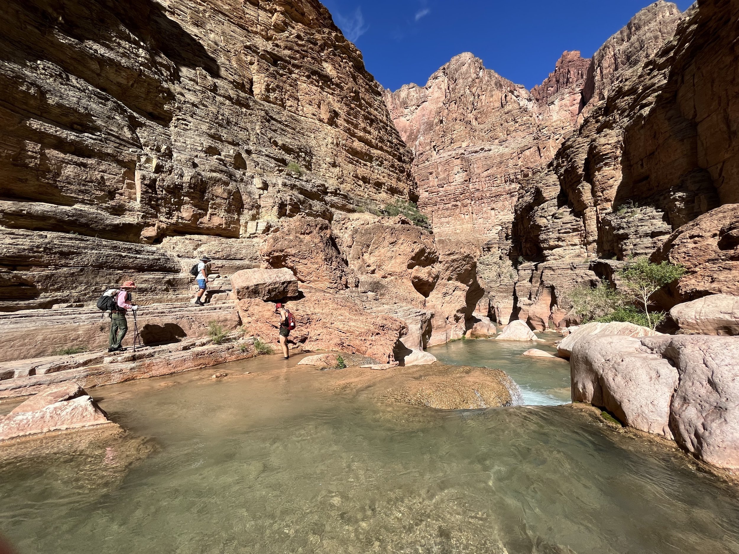
Sometimes the trail took us down by the river.

Which we had to cross several times.
Other times we were up high above the river working our way along cliff edges.


Camping is not allowed in this section so one can only do day hikes.
Several places had ladders and wooden steps to help us up or down sections of cliff.


Eventually we saw the sign to Beaver Falls.

And saw the falls below us.
We were headed to the Confluence and would have to check out Beaver later.
A sign pointed us in the right direction.

We are not sure how accurate this mileage was. Some hikers that were using GPS on their watches were coming up with less mileage. Another group thought it was pretty accurate.
Tracy was on a mission to make it to the Confluence so our pace was quick. There was only a couple of hikers that were faster. Tracy has been down the Grand Canyon 6 times with the last time being the captain of her raft. The Grand Canyon has a special place for her and she has wanted to do the hike to the Confluence for a long time.
The beauty of the canyon surrounded us.

The river

Canyon walls
Finally there was one last river crossing and a cliff to make our way around to where we would see the
confluence.

We are getting closer to the Colorado!

The Confluence where the blue water of the Havasupai river meets the brown water of the Colorado.
At the river level.

A group of rafters and kayakers pulled into the beach below us. We talked to them for awhile and Tracy compared rafting adventures with them. Most of their group hiked up to Beaver Falls.

Tracy spent some time taking photos and just enjoying being near the river. It is definitely one of her special places.
On the way back to our campsite, we ended up going back at different paces. Tracy was into chilling and I wanted to get to Mooney to go for a swim.
I didn’t get back in time to go for a swim, but I did get back in time to just enjoy the falls,
There were quite a few people waiting to climb up the cliff so I got in line and headed up. It was interesting to see the different climbing techniques. There were some that I would not recommend, but happy to say no one got injured. That was not the case for some other days
Ladders at the bottom when you start the climb. There is plenty of mist from the falls so the lower half of the climb is wet and slippery. We used biking gloves which were quite helpful.

One goes thru a tunnel on the way to the bottom of Mooney Falls.
I got back first and went to get water which was another mile walk. By the time we had dinner it was dark and time for bed. We have one more day at the falls and plan to see several falls that are closer to the campground.
Sept. 23
During the night, rain started falling. We were prepared for rain at our campsite, but there was no weather forecast that had predicted rain. By morning the rain had stopped, but a thick layer of clouds covered the surrounding mountains. We were glad that we had done our hike to the Confluence yesterday. After breakfast we put on our swimming suits and headed to Navajo falls. I had left my rain jacket in our van, but had brought my umbrella. I decided that even though the rain had stopped I would bring it along. There was no sign telling which way to go to Navajo falls, but there was what seemed to be a well traveled trail going in the right direction. All trails seemed to indicate that this was the way as well. We met Kayla who was also heading to these falls. She had gotten some information from locals who described the trailhead. It was good until we ran into a very overgrown and wet trail. We had taken a lunch break above Navajo falls on our first day. We saw people taking a trail down to the falls that was not the one we were on. Tracy and I decided to forget this way and head back to where we had lunch. When we got there we saw Kayla below us. She was just getting to the falls. We found a way down that was much shorter and very dry. Kayla confirmed that our way was much better.

Navajo falls.
Kayla, Tracy and I were the only ones here enjoying the falls. We took photos and enjoyed swimming There was even a falls that you could swim behind. It seemed pretty amazing that no one else was here. The rain is starting to become intermittent. Since we are wet, however, the rain doesn’t bother us.
The next falls that we want to explore is called Fifty Foot Falls. This fall is also unmarked, but directions have been given in blogs. There is a group of hikers that we encounter on their way to find the falls. They seem certain that they know the correct path With this group in lead we follow, it is more like a crash towards the sound of the falls. We cross over several streams with deep holes. I mange to get a nasty scrape on my leg from the sharp rocks. Once crossing the streams to our dismay, we are at the top of the falls.

Tracy looks over the edge and quickly determines that this is not the way and we need to go back.
We head back thru the streams and group up before heading down a path that is obvious. We meet a couple of hikers coming towards us that point out the way. It is quite easy and we realize we should have done some more scouting before crashing thru the forest.
Fifty Foot Falls.
There are several falls falling here. Swimming once again is my favorite activity. The current is strong and wants to push you down stream.
The rock formations are quite unique.

It appears that at one time there was a lot of water flowing over these rocks. The number of people enjoying the falls here has increased so we decided to head back to the campground and get some Fry bread. Kayla is going to join us. As we are heading back to the restaurant Kayla tells us about another falls that is rarely visited. It is called Hidden Falls and once again she was told of its location by some locals. We have a choice to go now or to after we eat. I think that since we are close to it, we should go now.
We head down a trail which takes us to the river. In order to get to the Falls, one has to wade along the shore and then cross over. We meet a couple who are returning from the falls. They give us some directions and soon we are checking out Hidden Falls. We decide that this falls is for looking and not for swimming.

Hidden Falls

We had to cross this to get to Hidden Falls.
We can now say that we have seen all the major falls and we should celebrate by having some Fry bread. As we head back to the campground. we see several hikers coming our way that we have talked to before. They tell us that the Fry Bread Restaurant is closed, but they are going to walk to the village where a women makes fry bread out of her house. By this time it is starting to rain and I opt not to go to the village. Tracy really wants to eat Fry Bread so she heads to the village with them. On a side note one of the women in the group teaches school in PA where I student taught may years ago.
It is starting to rain harder so I stop at the tent that has tables where the Fry Bread Stand is located. I have some lunch in my pack and figure that this might be a good place to eat it to see what the rain is going to do. The tables are soon filled by people waiting to see if the rain is going to stop. Then there is a crack of thunder and the skies open up with a down pour. Little streams begin to form on the trail. The creek begins to rise. Glad we are not camped near the river. Meanwhile Tracy and her new found friends haven’t made it to the village before the down pour and Tracy has become drenched.(She did not have a rain jacket.) Fortunate for her they have some spare clothing and she is able to warm up when they reach the restaurant. When the rain slows I head back to camp. Several people want to know if my umbrella is for sale. By early evening Tracy has returned and we eat our last meal at the best campsite. We make a plan to get up at 3:30 and depart camp by 5.
Sept. 24
We are on the trail, by 5 using our lights. There is no wind, nor rain and the starts are shining brightly. By 6 we are to the village. The rain of yesterday has made the sand more firm so hiking is easier and we move quicker. When we get to the village there is a long line of hikers waiting for the chance to take the 10 minute ride with the helicopter to the trail head. There is no guarantees and it is a first come service. The villagers have priority, but it seems that most of the time the people in line will have a chance at geting the ride. Tracy and I are opting to walk the 4-5 hour hike back to the top. The morning is cool and for most of the hike we are in the shade.

No complaints about the view.

We only take a couple of breaks. Our packs are lighter and we aren’t carrying as much water.
Around 8 am, we encounter hikers that are heading down to the campsite. Some only have day bags while others are carrying pretty heavy packs. We talk to a few, but most are focused on getting to the falls.

There must be a tradition of leaving a pebble in this rock.
By 10 we are on the top looking down to where we just came.
The last 2 miles are a steady up!

Tracy makes her way up the last several switchbacks.
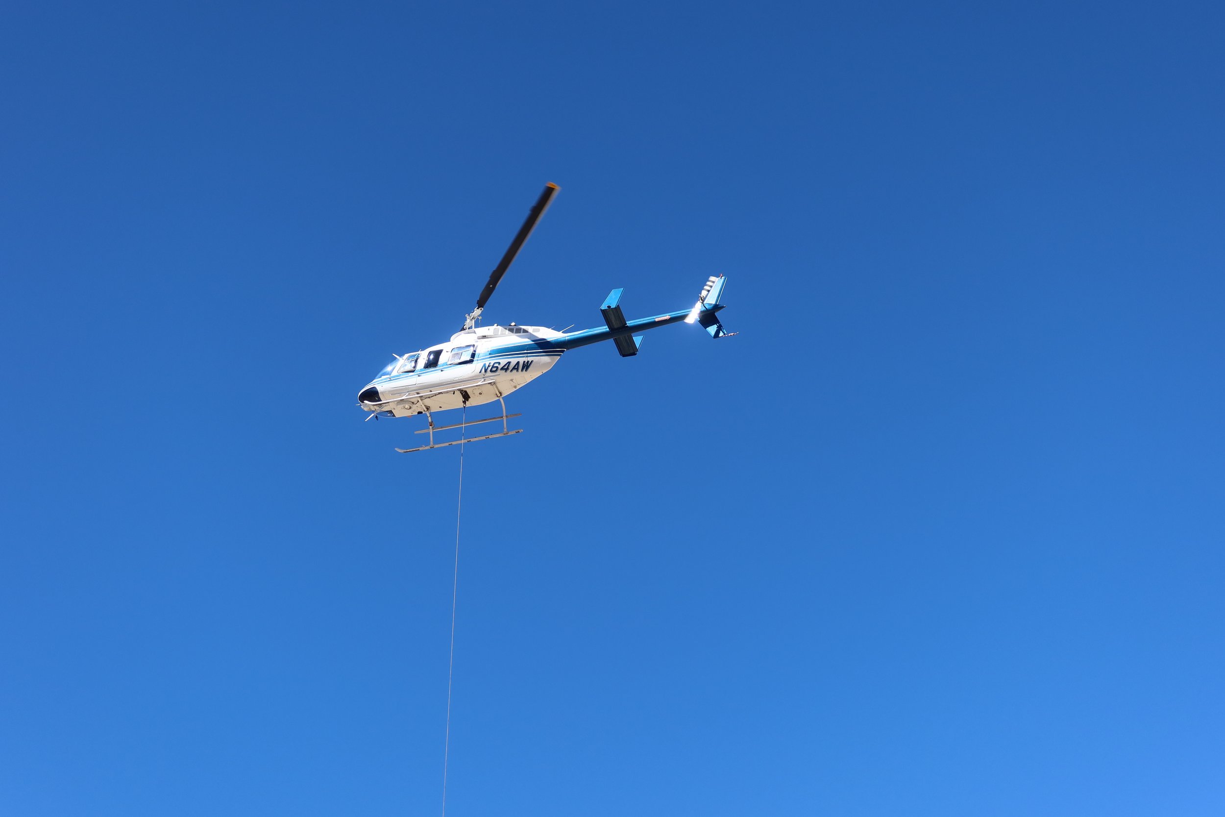
And then we are at the top! We hear the helicopter slinging gear of hikers.

and then the helicopter appears bringing up the hikers.
What a privilege we have experienced getting to see the blue water falls of the Havasupai.