March 30
One of our activities for the morning is head up to the cave visitor center and charge our electronics. Yesterday when we arrived there weren't any outlets available so hoping this morning we can get there before the rush. We had a little cell service so Don was able to download the weather forecast for Summerhaven, one of the sky islands that we need to hike thru,

The morning temps look cold!
Don stayed at the visitor center while I headed back to pack up camp. About 8:30am he returned with mostly charged electronics and we headed out.
On a trail that looked like this

For awhile it seemed like a stroll in the park which it was as we will soon be entering Saguaro National Park.
This has been a challenging year for the park with an increase of AZT hikers. One needs a permit to camp in one of the two campsites, but their permitting system is not set up for thru hikers. With the knowledge that this year has been challenging, the park sent out a memo that for this year stating even if you do not have a permit one should be able to find a place to camp at the campsites. We tried to get a permit but all the sites were full. One of the problems being that hikers were registering for several nights to be sure that they had a permit. We had our Park pass which is required.

So many saguaros and a variety of shapes.
The morning is still cool when we happen upon this reptile moving slowly across the trail.


We figured that since it was cool, the snake was moving really slow. We didn’t want to upset it so we gave it a wide berth.
It has been another day of not seeing any hikers, just some mountain bikers on the trails before the park boundaries. Just after seeing the snake, a couple of Park rangers came walking towards us.
We told them we had our park pass but were unable to get a permit for camping and that we had read what the memo from the park had said. Generally one can camp this year with out a permit and when you get to the campsite, see if you can find someone that does have a permit. One of the rangers said well that is not how it works and if you want to camp you need a permit. She continued to tell us the rules and said I can make you turn around. Interesting! The other ranger who let the woman do most of the talking, finally said , we are aware of the problem and I am on a task force working on it. It sure seemed that he was aware of what the memo had said. Finally she said have a good day, don’t leave any trash or have a fire. As soon as we get cell service I am going to find the memo and take a screen shot of it.
I can’t say that we were impressed with how we were treated!. The hike up to the campsite soon had us marveling at the beauty.

So much greenery!

The saguaros with the yellow rabbit bush was stunning!
So was the trail that had obvious signs of being built by the CCC

More flowers

We came to a junction to head to Grass shack campground. We immediately noticed that the trail was no long the quality of the CCC. As we were nearing the campsite, we heard a lot of pounding and came upon some park employees that were doing work on the trail. They had been there for several months and had been making slow progress. It once again was a appreciation for what the CCC did for our parks.

Heading up to Grass Shack.
When we arrived to the campground we were able to talk to one of the employees of the park. He said that each site could have 6 people and he thought there might be one across the creek that only had one person. We approached the campsite and a woman was there setting up her tent. We explained our situation and at first she said well if you can’t find a site come back here. We got the feeling that she didn’t really want to share. We looked around but this one made the most sense. We found a site not close to her and set up our tent. I grabbed our food and went down to the river to cook. She came down to where I was cooking and explained her situation. She was really fine with us being there and as we talked more discovered that we had mutual friends and that she had worked as a Leave No Trace instructor for NOLS. She later invited me over to her tent for tea and we had a nice conversation. Tomorrow we will be going up 3000 feet and hiking near Mt. Mica another sky island. On the trail after talking to the two park rangers we had enough cell Service to find the memo and take a screen shot. I guess we might be the ones that inform the park employees of memos from the park headquarters of current news!.
Miles hiked 15.5
March 31
We thought that it was going to be a cold night, but it never got below freezing. We have about 3000 feet of elevation to climb before we reach Manning Park which is at 8000 ft. We kept most of our clothes on as up we went. It was obvious that it was a lot colder at higher elevations when we passed this stream with icicles.

Glad we camped at the first campsite.
We found a sunny spot and pulled out our stove and ate a warm breakfast. The sun felt good and it warmed us up. On to Manning Park. When we arrived there were a group of pack horses and mules that were getting ready to head down the mountain. A park ranger and other park employees stay here. There was a fire going, but no invites for us.
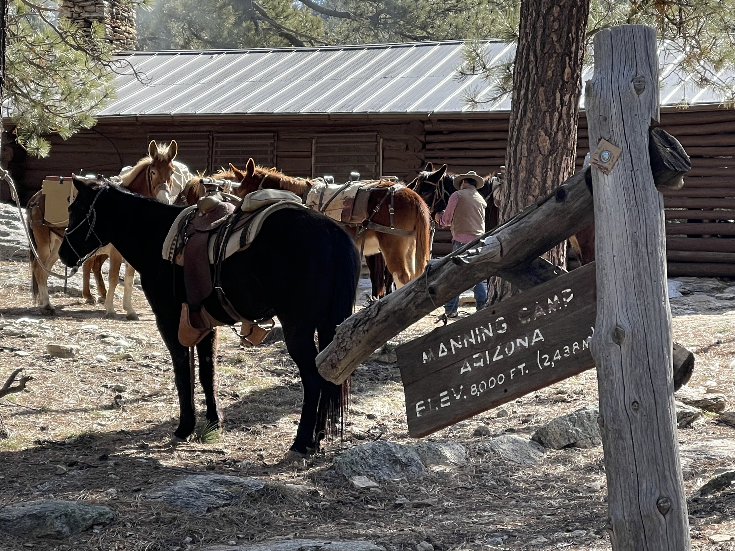
We were greeted by the park ranger who wanted to see our camp permit and park pass. We once again explained the situation and this time we pulled out the screen shot of the memo from the park. He read it closely and realized that we were not breaking the rules. He than asked us if we had a fire or left trash. He said I can give you a ticket if you did. Not sure if he realized that he was talking to an ex chair of the Leave No Trace Board. Anyway it was good to leave the park personal and hope they get a class on dealing with the public!
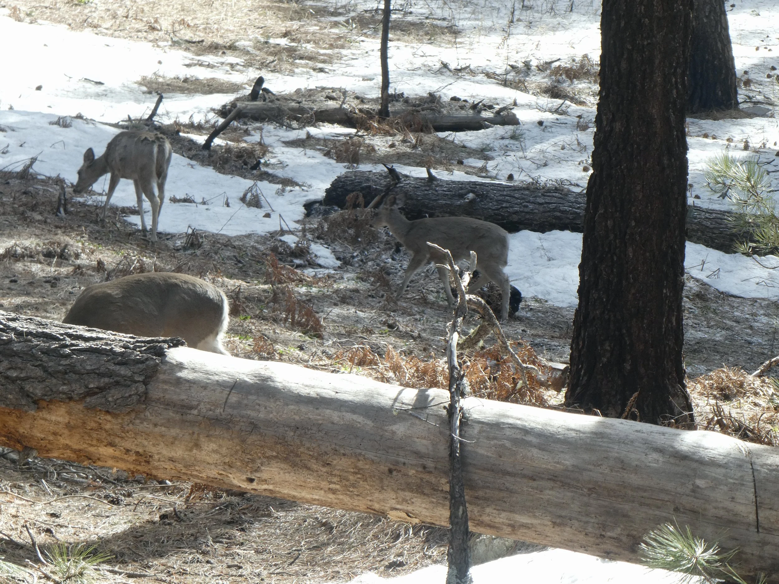
Some deer were hanging around the buildings.

Hiking thru the pines.
Quite the contrast from yesterdays hike being surrounded by cactus. Soon we will have about a mile of snow to navigate thru. Just before reaching the snow we meet two hikers called Apple Pie and Little Bird. Apple Pie has hiked all of the National Scenic trails in the United States. Some of the trails she has hiked more than once. They are going south bound and this is the third time and most likely the last time our paths will cross. They used micro spikes to navigate the snow, but by taking your time one should be fine.
It was pretty easy to hike thru the snow. It was still early in the day and the snow was mostly hard so no postholing.
We had been warned not to follow footsteps as they were not necessarily going the right way. This was good advice and we checked Far Out several times just to make sure. Once we got past the snow we were back into rocky terrain and began heading down hill once again. There is a pattern here as we go up and then down.;

Don checks out the valley below.

Quite the rocky terrain.;

Looking back at Mica Peak and all the snow.
Finally we reach the gate that marks the National Park Boundary and we have gotten thru the park without a ticket. When we reached Reddington Pass we were ready to call it a day. We crossed a dirt road and then went a little farther where we were out of sight. Lots of beautiful vistas today,
Miles Hiked 15.5
April 1
By 5;30 it almost light enough to see without a headlamp. Love these longer days! We were greeted by these morning glories.

Great way to start the morning. Don checks out Mica Peak as we continue heading down the valley after leaving Reddington Pass

Late morning, we walk past 5 tents that are just finishing packing up. This is the most AZT hikers we have seen at one place. One of the hikers, a man who calls himself Moose hiked with us till a water source. Trip was there getting water and shortly afterwards Numbers and two other hikers showed up. We filled up with water as we have a steep climb coming up and the sun is warming us the earth. The trail is steep and using our rest step we make it to the top. We are hiking on the weekend and the mountain bikers are out impressing us with their skills. In this area we share the trail so we are careful around blind corners.
Before heading up to the pass we were treated with some nice flat trail.
Then we got to experience some steepness!

When we got to the top of the pass and looked down to the valley below, we were surprised to see so much activity. A campground and day use area opened today and folks were taking advantage of the beautiful area. We passed by a resupply box and noticed that it was full of water. We plan to stop for lunch at the day use area. There is no potable water at the picnic area so we are thankful for the water in the box. We share a table with Moose and learn more about him. There is a lot of uncertainty of how much we will be able to hike in the northern sections due to the snow in the north. After lunch we head past the Molina Campground. We are now sharing the trail with a lot of mountain bikers and speed is a common thread. We do our best to avoid any encounters and happy to say that we are successful. Once we begin going downhill the bikers are no longer a factor in our hike.
Don and I decide to take a break in the shade at a small pool of water to soak our feet. Numbers shows up and joins us. She is in her early 60’s, retired and hikes as much as she can. We are impressed by all the hikes she has done and the ones that she is planning to do. Today is the day for meeting hikers. We went several days with not seeing any one and now we have met quite a few. A popular campsite is coming up called Hutch’s pool. Since it is the weekend and also the the number of AZT hikers has increased, we can envision that this place is going to be crowed. We want to start looking for a place to camp several miles before this popular place.
Our timing is such that we want to hike down Sabino Canyon before camping. Once we start down the canyon we realize that camping in this area is not an option. The trail is steep and there are drop offs.
It is hard to imagine hiking this trail with lots of snow. In several place the trail has been washed out and one has to be careful of their footing. Eventually we do make it to the bottom and campsite selections are pretty grim. Lots of brush and boulders occupy most of the terrain.
Then we spot a sandy spot nestled between boulders. It will be tight and we won’t be able to stake out the tent like we like to…. but we give it a go and make it work. The moon is bright and reflects off of the white granitic boulders. It is definitely a special place to sleep tonight.

Home for the night.
Miles hiked 17
April 2
The moon made it hard to sleep and I finally used my hat as a blackout eye covering. I was glad to finally be able to get up and head down the trail. We looked back towards that area that we descended last night and were thankful for the trail.

Before breakfast we need to cross a stream. First we try to find some rocks to hop, but realize quickly that is not going to happen so we put our sandals on and wade across.
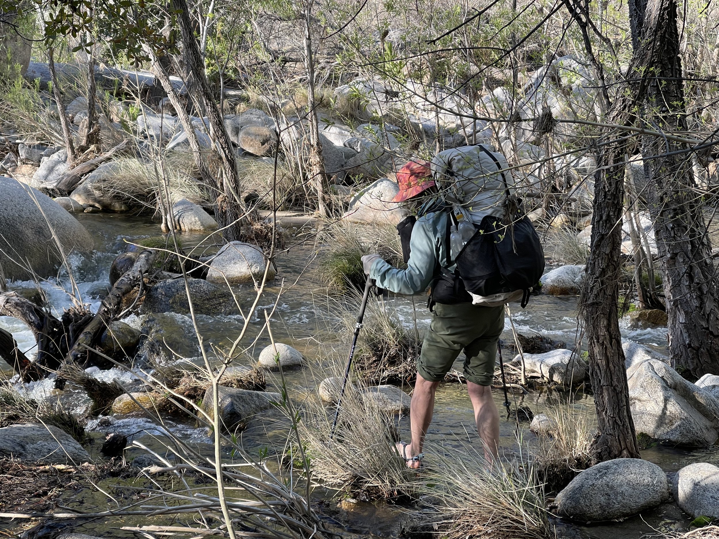
Several weeks ago the water here was more like thigh deep. Today it is below the knee and probably will continue to go down as the snow is mostly gone on this side of the mountain. The sun warms us up as we have breakfast on the other side. As we are finishing up our breakfast here comes Numbers. She likes to wait for the sun to hit her tent before she heads out. Numbers ends up leap frogging us for most of the day.

Today we are starting the push to Summerhaven. Our plan is to camp several miles before the actual town. We have a resupply box in the general store which will be our food for the next couple of days. The store doesn’t open til 10 so no need to get there early.
The trail thru the rocks is somewhat a scramble. One needs to look for carrions to find the trail. It is not too difficult just slow moving.

Mt. Lemmon is also a sky island as we look down at the plains below.

Don make his way up the trail.
We have carried extra water up from one of the streams and can share some with Numbers as she has run out.

So many rocks and such a contrast from the previous days going thru the dessert with all of the saguaros.

Eventually we get to Lemon Creek and have a late lunch. For the next several miles water is plentiful and we cross a creek numerous times.
There is evidence of fires that have gone thru the area in the recent years. As some of the trees have burned there are spaces that expose some of the non burned trees. Many of these trees have fallen due to a change in wind patterns. The only hiker that we have seen today is Numbers.
We are ready to call it a day when we see a flat area. Even though we haven’t made a lot of miles today, the miles that we did do were strenuous.. Tomorrow we may even have, a later to leave day, as there isn’t much to do in Summerhaven other than wait for the general store to open. Numbers is going to hike a little farther and get up later.
Miles hiked 12
April 3
Not a lot of hurry in our morning hike. we walk thru more burnt areas and down a stream bed that still has snow. the trail is washed out in places and we use Far Out to determine where it is. Eventually we make our way to a trail head. Most of the trail heads that we have encountered have informational signs, like these ones.

And this one.

The trail connects to a road which will take us on the mainstreet of Summerhaven. A community center has bathrooms that are opened 24 hours that hikers can use. The post office is also opened for 24 hours that some hikers use for sleeping. With number of hikers increasing this space may not be available in the future. The wind is picking up and we use a side of the community center for a wind break while we wait for 10:00. There is good cell service here and we connect with Tracy who is going to meet us at the Tiger Mine Trailhead in a couple of days.
At 10:00 we head to the store, get our package and get our free hot chocolate or coffee for being a hiker. Numbers convinces us to get a sandwich. It is prepackaged and normally not what we would purchase, but it is our only option today as the restaurant is closed. Guess we are hungry for bread as it tastes pretty good. The cookie cabin doesn’t open for another hour and we are ready to take off and hike Oracle Ridge. We also meet Harry Potter here who is an opportunistic hiker. He hikes the trails but also enjoys getting off trails if there are interesting things to do.

Looking back towards Mt. Lemmon.Some years there is not enough snow on the mountain to open the ski resort. This year the resort stayed open much later than usual.
Any hope of having an easy hiking day was soon realized( this was not going to happen) as the trail went up or down and the numerous rocks on the trail made for tricky foot placement. The wind was also gaining in strength and several times we had to brace ourselves to prevent falling into a cactus. The temperature is going to drop tonight with predicted temps being below freezing. We are hoping to get down in elevation so we will below the freezing temps.
We pass by a hiker from England who has found a site surrounded by trees. We stop for a short chat and he tells us about hiking in England and Scotland. (more ideas to add to our bucket list.) Numbers catches up to us while we are taking a break in the shade and eats her second sandwich, making us wish that we had gotten another one as well. I guess we are ready to eat town food for awhile.
It is great to see a horned toad hanging out by the trail.

Horned Toad.
We pass by a water tank that Numbers is figuring out how to get water. We decide to go by it and hope to get water at the High Jinks ranch. The wind is even stronger and once again we find ourselves looking for a protected place to camp.
We see a sign saying High Jinks Ranch. with the words, water, camping and lodging. We had heard that this ranch was under new ownership and it was unknown if hikers could stay here. As it was getting late, we thought it wouldn’t hurt to ask and we could get some water here. There was a sign saying “ring the bell for assistance.” So I did and a woman appears and when I ask if we could camp the answer is affirmative. We find a place for our tent which has some protection and cook up dinner. Meanwhile Harry Potter arrives and is also looking for a place to camp. He is also given the okay so after a bit of conversation which includes a very interesting uber story of Harry Potter actually driving the Uber ,as the driver did not like driving the car on mountain roads, we head to bed.

At one time the High Jinks Ranch was a well known working ranch.

And had some famous people visiting it.
Miles hiked 18
April 4
We were able to reach Tracy by phone last night and confirm that we would be out today. It was a couple of days faster than we had originally planned, but fortunately she would be able to come and get us.
The easiness of the trail made up for the harder trail of yesterday. In fact we got in 10 miles before 10:00. It was a combination of easy trail and having the end of trail syndrome. It was a chilly morning which also made for fast walking. At one of the road crossings we met Trip who was just getting let out of a car by a Trail angel. He had gone in to Oracle the night before to do laundry and get food for the next section. After talking to him we found out that his filter had frozen and was not reliable. This next section that he is doing is the one that we had done first. Most of the water comes from ponds or tanks that usually have a cow presence around them. If he couldn’t filter water, he would be carrying lots of water. We quickly realized that we were heading back to town and that we should give him ours. It was a passing it forward of all the trail magic we have been given,
Tracy originally thought that she might ride her bike out to meet us, but with all the wind the air was quite dusty and we advised her it wasn’t a good day for biking.
Before long we saw the signs welcoming us to the Arizona Trail at the Tiger Mine Trail head, We have now walked from the Border to Payson for a total of 385 miles. We did do a flip and flop which allowed us to enjoy the super bloom of the dessert when it wasn’t to hot and go thru the sections with snow after a lot of it had melted.
Tracy picks us up and takes us back to our van which has been parked at the SW NOLS branch. First though we celebrate our hike by eating at a small Mexican restaurant which reminds us of our time in Baja.

The food was delicious!
Back to the van which we are happy to report was Pack Rat Free!. As Tracy was driving us back to the van she realized that Easter was this Sunday. She suddenly said I need to take you to see the Pascua Yaqui tribe and their celebration of Easter. We didn’t have to be back in San Diego for a couple of days and this seemed like a very interesting opportunity. We made plans to go Thursday evening and Saturday. I plan to write some of the things we observed on another blog post. There will be no photos as cameras, phones etc. are prohibited.
We are unsure if we were coming back to hike any more of the trail. Reports of hikers going north of Payson was that the trail was covered in snow and if they made it thru they were most likely getting off at Pine. We would be gone for almost 3 weeks and figured a lot could happen with snow melt.
We will be watching Far Out and reading about other hikers and seeing what they are experiencing.
We are glad to have done as much of the trail as we could, considering the conditions of the trail this year.