April 28
After a hectic day, we were thankful that we could sleep in till 7. Never complain about sleeping in our van in our bed! The morning’s activities included looking at the food for our next two ration. We have been eating less than we originally planned. Since food is one of the heavier items we carry, we wanted to par it back to where we didn’t end up with too much extra food. Never want to run out so it is a bit of a balance. We also wanted to relook at our clothes. That is another balancing act, but we did get rid of a couple of things. We always remember that ounces turn in to pounds. While we were finishing packing our packs, we get a text from Numbers. She is having a difficult time getting a ride so we tell her we will come and get her. It is only a 15 mile drive. After picking her up, we decide to take a drive to Mormon Lake. The store there has just opened and will take a hiker’s resupply box. We also just want to check out the area and see if there is still snow. There was a record snow fall this year. At Mormon Lake they received 28 feet. As we drive into the very small town, we see that there is water in the lake. It has been dry since the 90’s. At one time it was the largest natural lake in Arizona. We drop off our box and drive to a lookout to see the lake. The employees at the store hope the water stays.
We head back to Pine and have breakfast at the Early Bird Cafe. Don drops Numbers and I off at the trailhead and then parks the van back at the RV park. It has been a busy day and our plan is just to hike to the first water source which is about 5 miles down the trail. The trail is well maintained and we are enjoying the scenery. At the small creek, Don and I find a place to camp. Numbers wants to hike a little further so she can sleep in till the sun hits her tent. None of this getting up at first light! We make a plan to meet at Weber Trail Head tomorrow.
Miles hiked 5
April 29
We are up at our usual time and on the trail by 6. Today we will be heading up and finally on to the Mogollon Rim.

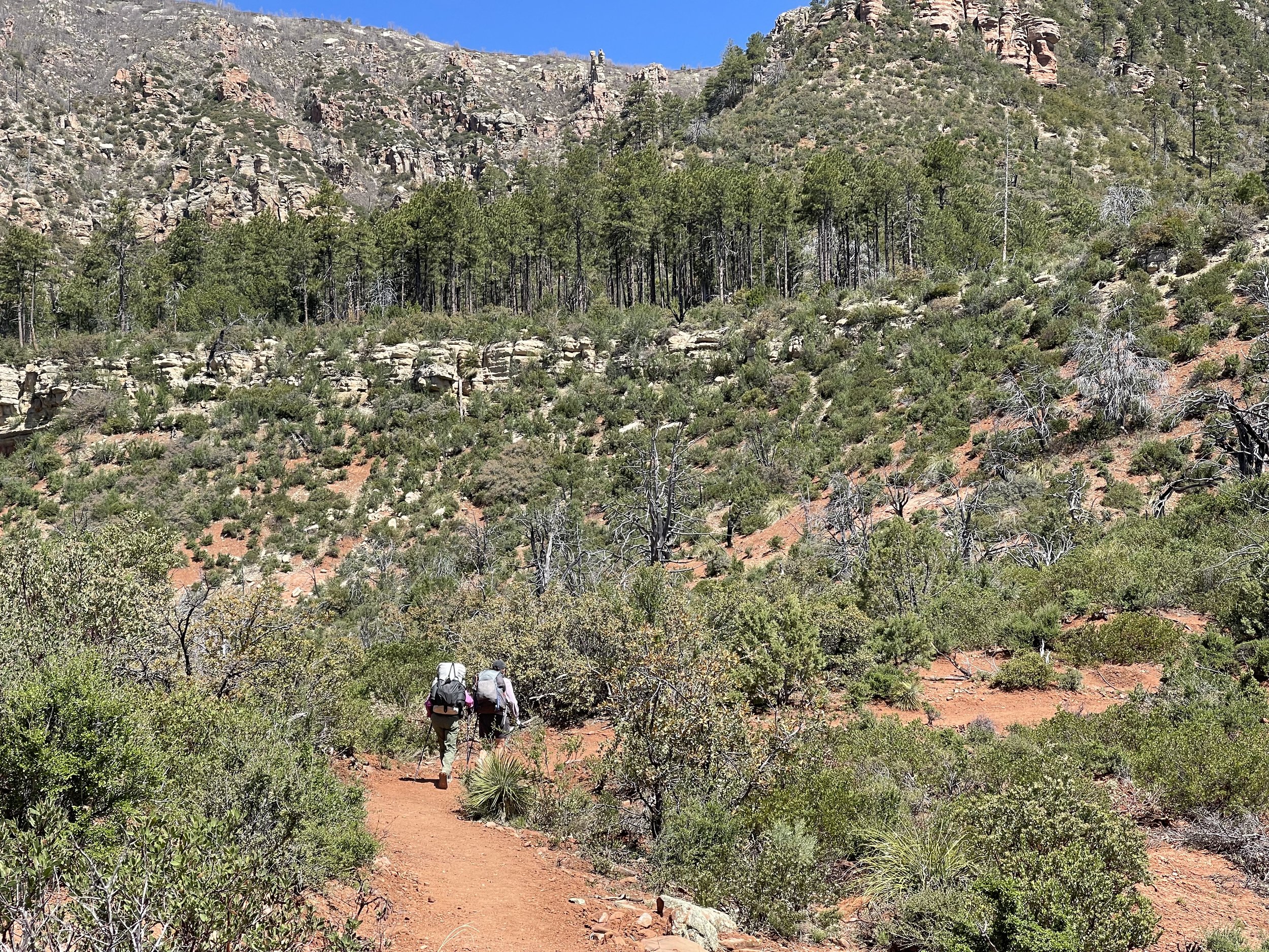
We will definitely be adding some elevation gain today as we make it over the Mogollon rim. The Mogollon rim has a large AZT presence. After hiking the southern sky islands, the next big challenge is the Mogollon Rim. The rim got lots of notice this year due to all the snow. Early hikers used snowshoes. and posted photos of being able to just walk over the AZT gates. (not to mention the high river crossings) Our timing of hiking there now seems to be the sweet spot. Most of the snow is gone and the river crossings are quite reasonable. The other challenge though is if you hike right after the snow, the mud is thick on the trails. We will have to wait and see if the mud posses any problem.
The sky is the deep blue of Arizona today.

We can see the outline of the trees on the rim.

Great mountain views today.
After hiking for several hours we arrive at the Webber Creek trailhead. Numbers has just crossed to the other side. Our plan for the day worked out, she got to sleep in and we got up at our usual time.
After breakfast, we are ready to hike on.
We all comment that this trail is one of the best one that we have been on so far. There are very few rocks and most of the trail is a good grade.

Part of the trail go thru mature forests. Most of the drainages have water,
The trail also goes thru some open spaces.

We are cruising along and then at a junction there is a lot of shrubbery on the trail. It is obvious we can’t proceed on the newly worked on trail. It is a detour through a trail that is quite brushy. Fortunately it is not for long. We pass by a work grew that impresses us with all the tools they carried to where they are working on the trail.
We hear chain saws and a vehicle ahead. We wonder how it could have gotten here. As we round the bend first we see the wagon that holds the tools.

Again we are impressed with the work involved to get the tools here. This cart is human pulled. Then we see the vehicle which is doing some major rerouting. It sure makes us appreciate all the work that goes into building trails.

Water is so plentiful here, we usually only have to go a mile or two between water sources.
There is even a bridge on this section.
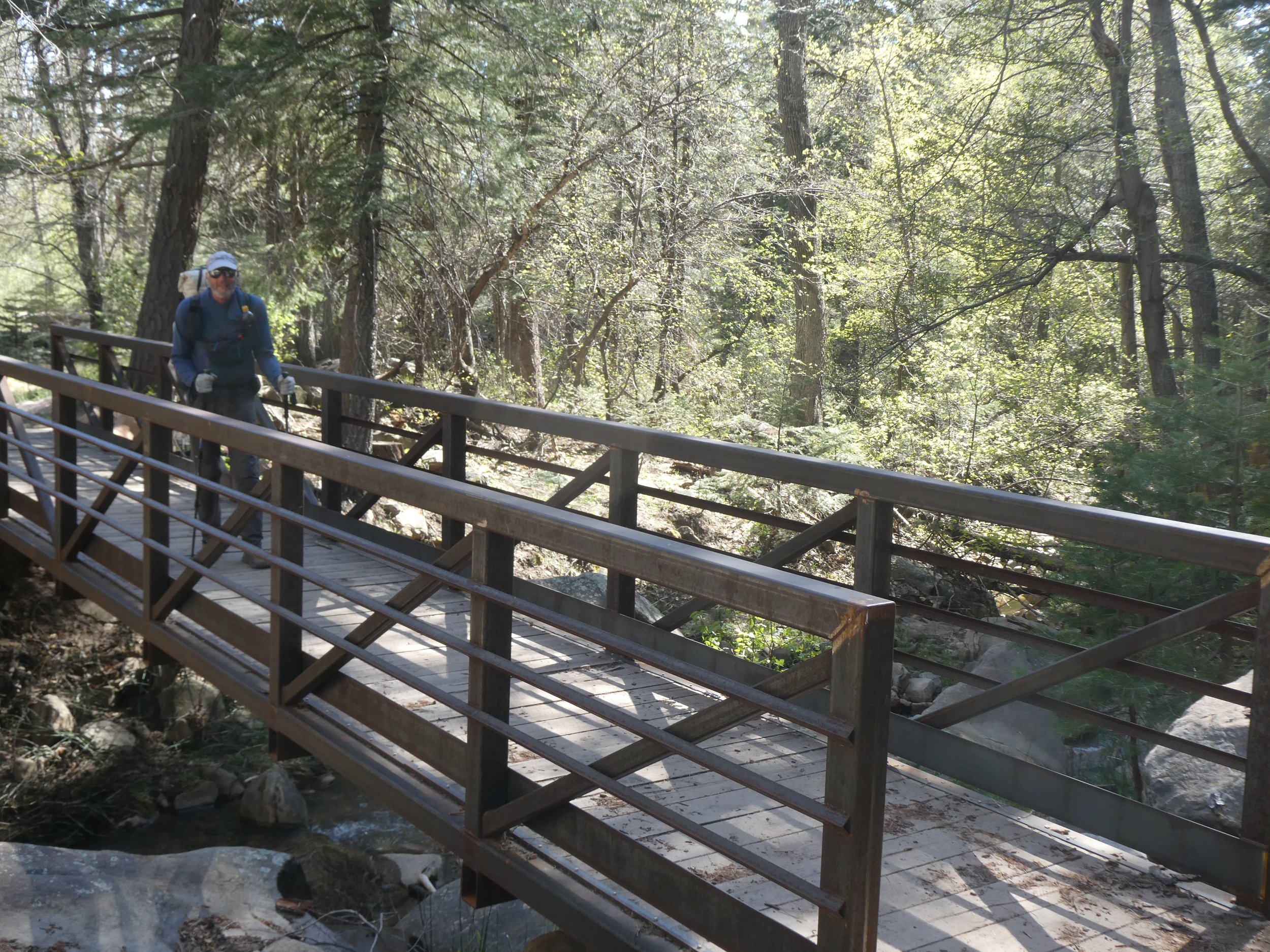
A rarity on this trail.
Once we cross the bridge it is time to do the final accent to the rim. It is late afternoon and the sun is hitting us full on. Our smooth path has turned to rocks as we hike the final 3 miles to the rim.

Don and Numbers take a short break in the shade and look ahead to the next rocky stretch.

Step by step we reach the top.
There are patches of snow and the ground is quite saturated . We hike to General Spring Cabin which was built in the early 1900’s There is a spring here and some almost dry ground. Don and I decide to stop and Numbers moves on, telling us she will camp near the trail in a couple of miles. Don watches Numbers as she hikes up the hill in front of us. With a plan decided we make dinner and go to bed.
Miles hiked 19.5
April 30
We thought that it might get below freezing last night and slept with our water filter, but by morning temperatures were above freezing. Our plan was to hike till we saw Numbers camped along the trail, then hike together till we reached Clear Creek. Since the last time we saw Numbers heading up the hill, we assumed that that was the trail! There were plenty of foot prints, however as time passed we wondered where was Numbers. We checked Far Out and it seemed that we were close to the trail but not really on it. It was to the East of us. We headed out cross country and came to a cliff. The trail was below us, but we would not be able to reach it unless we headed back to the cabin near where we had camped. We had already gone several miles and didn't like that option. We were on the power line trail which some hikers had taken instead of going down to the actual AZT. As we checked out the trail further we realized that these two trails would join. Our hope was that Numbers would head down the trail when we didn’t show up. It was an easy trail to the Clear Creek River. The water was quite cold and the bottom rocky, but we had carried sandals and they were quite useful.

There was some great shade trees on the other side so we made ourselves comfortable and hoped we would see Numbers. This was the river that the first hiker of the season to arrive here had to swim. That would have been way out of our fun range.
We waited, watching where the trail came down to the other side. There was a hiker who appeared who decided to wade the river barefoot. His face gestures made us happy that we had our sandals. When he arrived to where we were sitting, we asked if he had passed Numbers. He said No, because like us he had missed the trail junction and hiked the powerline trail. He talked to us for awhile while we waited and hoped to see Numbers. Finally she did come and said that she had waited and when another hiker came that hadn’t seen us she realized that we must have missed the junction. The trail that she did had some slippery snow and some very wet areas along with Creek crossings. Can’t say that we missed doing that section. The other hiker stayed to talk with Numbers and she knew his name(Malto) as he has been hiking for quite a while and has written blogs. We won’t see him again as he averages 30 plus mile days!
It was good to have the three of us back together and next time we will really make exact plans of where to meet with options.
Next stop was Blue Ridge Campground which will be opening tomorrow. The host was there and the sites were ready to receive campers. The water was turned on and we enjoyed sitting at the picnic tables for lunch. It was another day of mostly flat land hiking which makes the miles go quickly.

We stopped by a nice water source before finding a place to camp. Numbers, once again is going to hike another couple of miles while we are going to make camp. She will be near the trail and will wait until 7. We hope there won’t be any confusion tomorrow.
Miles hiked 19.5
May 1
It is great to have the birds be our alarm clock. As soon as it is first light they start chirping. By 6, we are starting to hike down the trail. We are focused on finding Numbers. I think we were even going a little slower as our eyes had to change between looking at the trail and looking for Number’s tent. We knew we were on the trail and determined not to pass her campsite. Almost exactly two miles there she was waiting for us. We headed out to our first water source called Homestead tank. The description was that the tank is full, however, you might want to go to the next one. We agreed with that assessment and since we weren’t in dire need of water we continued on. The next tank had quite the interesting name.

It would be interesting to know the history of this name. The tank still had a brown color, but we were able to filter it and it came our clear.
The trail continues to be quite flat. we alternate hiking between pine trees and burned forests.
We are enjoying the pines….

and then the next couple miles will be burned forests with lots of deadfall.


We finally see our first snow patch of the day. In the last three weeks there has been a major melt.

Spring beauties and buttercups are springing up where the snow patches have gone.

Sure sign of spring in the air!
More flat trails as we hike towards Mormon Lake. Our plan is to get to town mid morning. We are not sure what are the amenities there.

Flat trail makes for higher milage days.
We make it to an overflowing tank with a clear stream below it. Don who has been walking behind us has gone around some downfall and mistakenly picked up a wrong trail. When that trail started going up, he checked Far Out and saw his error. We were glad to see him hiking towards us.
Don finds a dry spot and calls it home. Numbers also decides to stay here. Our plan is to meet at Mormon Lake tomorrow.
Miles hiked 22